


Horizon Explorer AR
คำอธิบายของHorizon Explorer AR
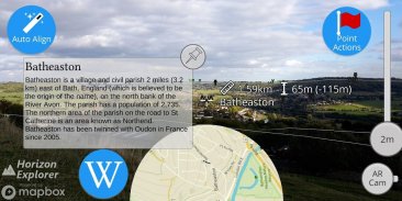
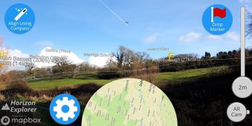
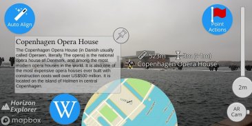
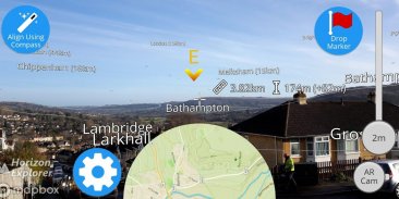
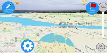
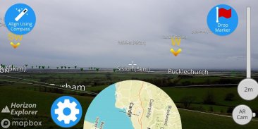
Point your camera at a landmark you can see on the horizon (eg. Hill, Mountain, Road, Lake, Building) and see:
- Name of the landmark
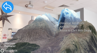
- Distance from you
- Altitude (& relative to you)
- Map of surrounding area
- Nearby towns and cities
- Wikipedia info for any landmark with a Wikipedia page
- Direction from you (eg. Northwest)
- Directions to landmark (opens in google maps)
- Street view for where you're pointing (opens in google maps)
Or use 3D Map mode:
- See terrain laid out in front of you
- Move phone to fly around the map
- Roadmap / satellite / hybrid
- Search & display 3D-maps for anywhere worldwide
- Distance, altitude and landmark names
- Infinite scroll
Horizon Explorer works worldwide, but works best on top of a hill with an unobstructed view of your surroundings. You can drag the horizon line with your finger to line up with the camera if the automatic tracking is not working very well. Or try waving your phone around in the air in a figure 8, then pressing "align using compass" to calibrate the compass.
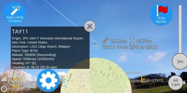
Live airplanes can also be enabled, starting from $0.99. Point at a plane and see the flight number, origin, destination, altitude and current airspeed of any commercial airline plane you can see.
If you are in a tall building, or otherwise not standing on the ground, enable "Tall Building mode" and optionally set your altitude using the slider.
Horizon Explorer will show mountain names, lakes or forests, the names & designations of roads, and many buildings.
Wikipedia Information will be displayed for anything that has an English Wikipedia article with a location set.
This app uses Google's ARCore to do augmented reality. This technology is currently available on ~50 phones: https://developers.google.com/ar/discover/supported-devices
If you don't already have the latest ARCore app installed, you will be prompted to install / update it from the Play Store when you first open Horizon Explorer.
หันกล้องของคุณไปที่จุดสังเกตที่คุณเห็นบนขอบฟ้า (เช่นเนินเขาภูเขาถนนทะเลสาบอาคาร) และดู:
- ชื่อสถานที่สำคัญ
- ระยะทางจากคุณ
- ระดับความสูง (& ญาติกับคุณ)
- แผนที่บริเวณโดยรอบ
- เมืองและเมืองใกล้เคียง
- ข้อมูล Wikipedia สำหรับจุดสังเกตใด ๆ ที่มีหน้า Wikipedia
- ทิศทางจากคุณ (เช่นภาคตะวันตกเฉียงเหนือ)
- เส้นทางไปยังจุดสังเกต (เปิดใน Google แผนที่)
- สตรีทวิวสำหรับตำแหน่งที่คุณกำลังชี้ (เปิดใน Google แผนที่)
หรือใช้โหมดแผนที่ 3 มิติ:
- ดูภูมิประเทศที่วางอยู่เบื้องหน้าคุณ
- เคลื่อนย้ายโทรศัพท์เพื่อบินไปรอบ ๆ แผนที่
- แผนงาน / ดาวเทียม / ไฮบริด
- ค้นหาและแสดงแผนที่ 3 มิติสำหรับทุกที่ทั่วโลก
- ชื่อระยะทางระดับความสูงและสถานที่สำคัญ
- เลื่อนไม่มีที่สิ้นสุด
Horizon Explorer ใช้งานได้ทั่วโลก แต่ทำงานได้ดีที่สุดบนยอดเขาพร้อมทิวทัศน์ที่ไม่มีสิ่งกีดขวางรอบข้างของคุณ คุณสามารถลากเส้นขอบฟ้าด้วยนิ้วของคุณเพื่อจัดแนวด้วยกล้องหากการติดตามอัตโนมัติไม่ทำงานได้ดีนัก หรือลองโบกโทรศัพท์ของคุณไปในอากาศในรูปที่ 8 จากนั้นกด "จัดตำแหน่งโดยใช้เข็มทิศ" เพื่อปรับเทียบเข็มทิศ
เครื่องบินสดสามารถเปิดใช้งานโดยเริ่มจาก $ 0.99 ชี้ไปที่เครื่องบินและดูหมายเลขเที่ยวบินต้นทางปลายทางความสูงและความเร็วปัจจุบันของเครื่องบินของสายการบินพาณิชย์ที่คุณเห็น
หากคุณอยู่ในอาคารสูงหรือไม่ยืนอยู่บนพื้นดินให้เปิดใช้งาน "โหมดอาคารสูง" และตั้งค่าความสูงของคุณโดยใช้แถบเลื่อน
Horizon Explorer จะแสดงชื่อภูเขาทะเลสาบหรือป่าไม้ชื่อและชื่อถนนและอาคารหลายหลัง
ข้อมูล Wikipedia จะปรากฏสำหรับสิ่งใดก็ตามที่มีบทความ Wikipedia ภาษาอังกฤษพร้อมระบุตำแหน่ง
แอปนี้ใช้ ARCore ของ Google เพื่อเพิ่มความเป็นจริง ปัจจุบันเทคโนโลยีนี้มีให้ใช้บนโทรศัพท์ ~ 50 เครื่อง: https://developers.google.com/ar/discover/supported-devices
หากคุณยังไม่ได้ติดตั้งแอป ARCore ล่าสุดคุณจะได้รับแจ้งให้ติดตั้ง / อัปเดตจาก Play Store เมื่อคุณเปิด Horizon Explorer เป็นครั้งแรก
Horizon Explorer AR--เวอร์ชั่น1.23.0
(23-04-2020)Horizon Explorer AR - ข้อมูล APK
เวอร์ชั่น APK: 1.23.0แพ็คเกจ: com.arrowsd.horizonexplorerเวอร์ชั่นล่าสุดของHorizon Explorer AR
เวอร์ชั่นอื่น


แอปในประเภทเดียวกัน


